Q&A - Ask Away! I'll Answer pt. 6
There was an overwhelming number of questions this week! If your question isn't answered in this post, message me, email me, etc. Please keep sending me questions because I want to answer all of them.
As a reminder, you can submit questions in the comment section of this post or email me directly through the website contact form. You can also send questions through any of my social media platforms. Find me @leahwx11 on Facebook, Twitter, and Instagram. If I miss your question, keep commenting on futures posts! I want ALL your questions answered.
Question - How many days a week do you work?
I consider myself a full-time meteorologist and part-time reporter. On days I report I still create forecasts and posts for my weather pages. On my off days, you better believe I am looking at weather models, following the latest atmospheric trends, and posting when needed. My position is very unique. I never work a regular 9 a.m. to 5 p.m. shift Monday through Friday. Nope, my work-week begins on a Wednesday and lasts through Sunday. On Saturdays and Sundays, I work from 4 a.m. to noon. Then Wednesday through Friday I cover reporting (unless I fill in for someone else on the weather team). As a reporter, generally, I cover weather, science, environmental, or outdoorsy stories. If it is a busy news day, I get assigned what is called general assignment stories. I love my shift and the many hats I wear. The work environment is ever-changing, and I love meeting new people in the community and telling their stories.
Question - Why is cloud cover measured in 1/8? Why not 1/10?
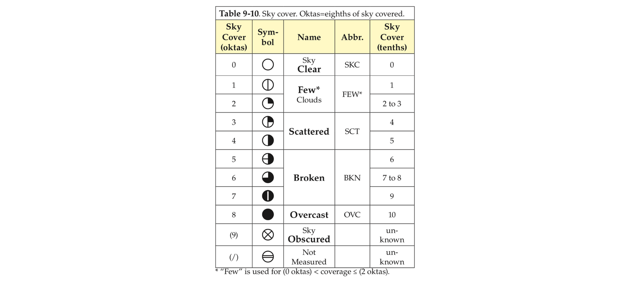
In meteorology, we measure cloud cover in eighths or okta. When you look up into the sky you can mentally divide the dome above you into boxes, with all visible clouds divided into these boxes. A cloudy box equals one okta.
So, sunny skies equal zero oktas. Partly cloudy skies are about four oktas, and cloudy skies are eight oktas.

While I didn't find the history behind why we use an ⅛ instead of a 1/10 when measuring cloud cover, here are some thoughts. ⅛ is much easier to compute when looking at the sky. Two, the atmosphere makes a dome above our head. If flattened, the dome would form a pie-like circle. The symbol for an okta is a pie chart cut into eight pieces.
Question - Does the axial tilt of the Earth vary, and if so how much does that affect the weather patterns?
Short answer - The tilt of the earth is what causes our seasons. As the heating and cooling of the earth throughout the seasons vary because of the tilt, it changes our weather patterns.
The video below provides more visual details...(Thank's Youtube)
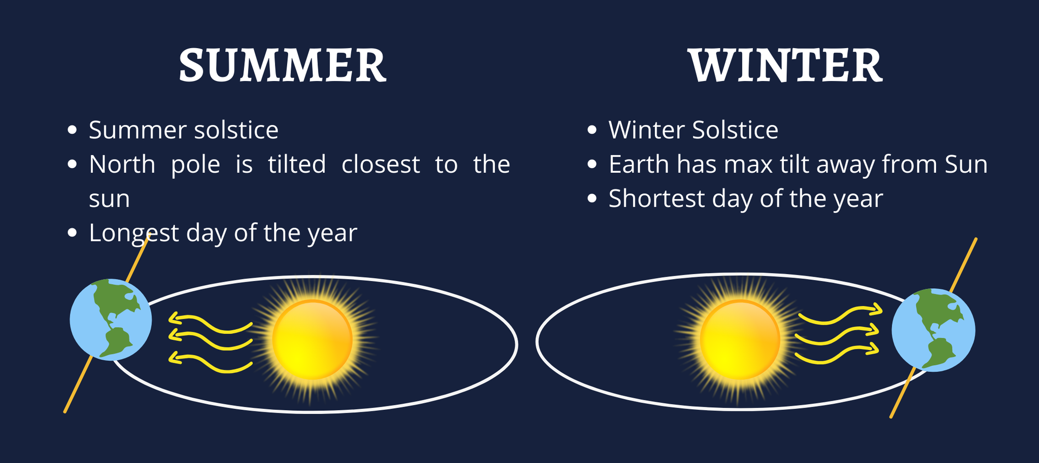
Long answer - Think of Earth's axial tilt as an imaginary pole going right through the center from "top" to "bottom." Earth spins around this pole, making one complete turn each day. That is why we have day and night. The seasons occur because the Earth does not stand up straight and has a tilt of 23.5 degrees. As Earth orbits the Sun, its tilted axis always points in the same direction. Because of this tilt, parts of Earth get the Sun’s direct rays during different parts of the year. So, when the North Pole tilts toward the Sun, we have summer in the Northern Hemisphere. And when the South Pole tilts toward the Sun, we have winter in the Northern Hemisphere.
The day the North Pole is tilted closest to the Sun is called the summer solstice, which is the longest day (most daylight hours) of the year for the Northern Hemisphere. It is also the day that the Sun reaches its highest point in the sky. Winter solstice occurs when one of the Earth's poles has its maximum tilt away from the Sun. The shortest day of the year.

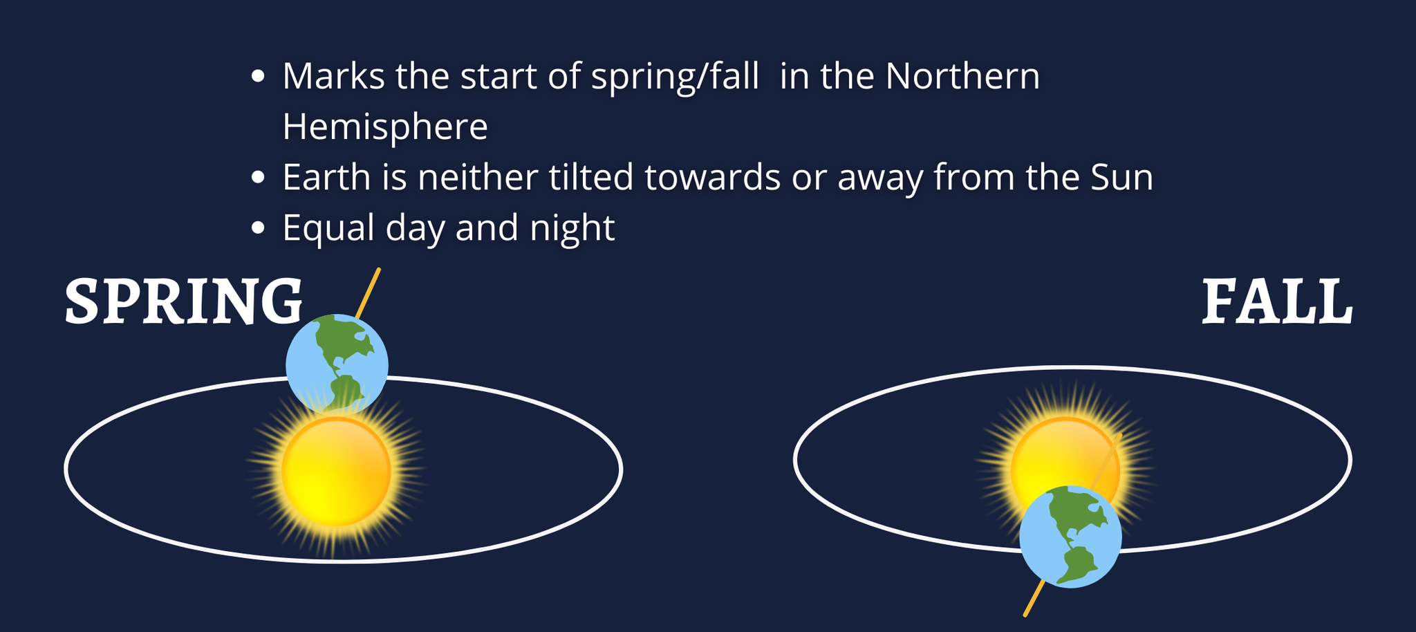
During the spring and autumn equinoxes, the Earth is neither tilted towards or away from the Sun. Hours of daylight and night are roughly equal during the equinoxes.

Question - I know a lot of the country had ice storms. Why did we get snow instead of ice?
It all comes down to the temperatures. Our temperatures here in the Ozarks were well below freezing. We were sitting in the 20s before the snow moved in. When snow moved in February 14th through the 15th, and again late February 16th, our temperatures were in the teens, with even colder overnight low temperatures. On top of this, all layers above the surface were well below freezing. With a little moisture present and some lift, we had prime conditions for lots of snow. The winter storm maintained its strength as it moved east and entered a favorable region for snowfall. Basically, in our area, nothing was acting against the snow. Areas with ice storms had more warm air intrusion that prevented precipitation from falling as snow. This warm air was either just above the surface, melting the snow just before hitting the ground, or in the lower levels of the atmosphere below the cloud base.

0 Comments Add a Comment?